Exploring History: Unveiling the Secrets of Mahasthangarh.
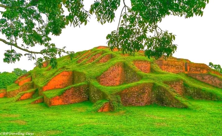
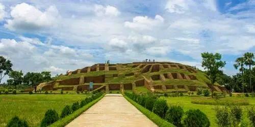
Mahasthan garh. Now in Bangladesh, it is one of the oldest monuments. Earlier its name was Pundravardhan or Pundranagar. Once Mahasthangarh was the capital of Bengal. In 2016, it was declared as the cultural capital of SAARC. Many traces of Maurya, Gupta, Pala, Sena empires have been found here. Its location is in Shibganj upazila of Bogra district.
Area and situated.
Mahasthan Garh is located about 13 km north of Bogra city on the west bank of Karatoya river.
History of mohasthan garh and what is there.
Mahasthangarh is the oldest city of Bangladesh. Although carbon-14 dating found a layer at Uari-Bateshwar 30 years older than Mahasthangarh, Mahasthangarh is by far the most important archaeological site in Bangladesh in terms of the extent of the city and the abundance of evidence obtained.
Pundranagara, the capital city of Pundravardhana, the kingdom of the “Samvangajas” is located here. The oldest written records of Bangladesh were found in Mahasthan; Written in the Magadhi-prakrit script of the 3rd century BC, the central ruler instructs the local ruler to lend rice, wood, oil and currency to the neighboring people in times of calamity and to take it back when the day comes.
Not only in writing, but also through numerous other material signs, it is possible to depict the urban planning, governance structure, social system, education system, architecture, in short, a complete chapter of the history of Bengal.
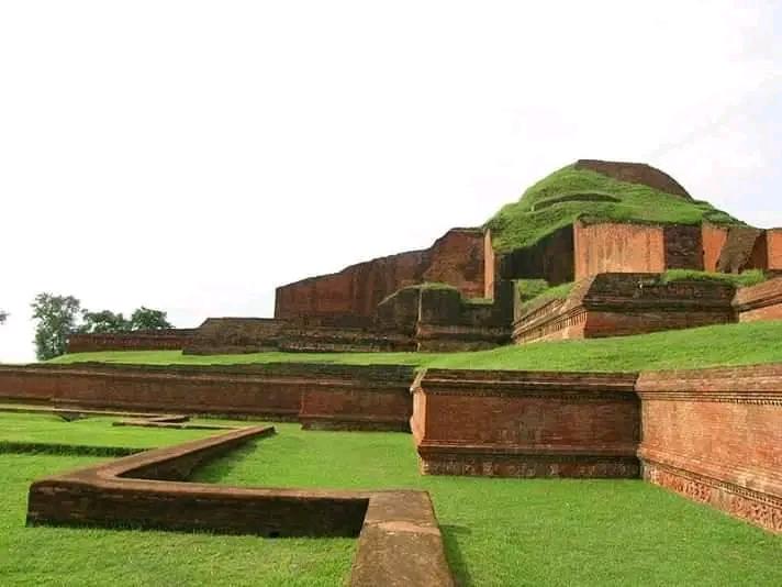
Many buildings, some of them palaces, some administrative buildings, some viharas, some temples have been built in different parts of this region because of the strong rule established here for a long time (at least 2000 years). Wells, ghats etc. have also become important due to different events of different times.
Many historical buildings and monuments can be seen together in Mahasthangarh like ‘Lalmai Complex of Structures’, ‘Shatgambuj Complex of Structures’, ‘Puthia Complex of Structures’ and ‘Panam Complex of Structures’ which were built later. But none of them compares to Mahasthangarh in terms of time. If the government could have completely acquired the Mahasthangarh area and presented it with proper excavation and preservation, then it would have been possible to tour ancient Bangladesh by visiting this area. Apart from gaining knowledge and experience of the ancient history of Bangladesh, huge amount of income could also be earned through tourism. But this is exactly where the government failed.
And the main reason for that failure is possession. Naval Minister Shahjahan Khan said in Parliament that the first act of occupying anything is to build a mosque (2 March 2011 Dainik Ittefaq). Mahasthangarh is no exception. The period of occupation has also started here with the mosque itself. There was a hermitage of a certain Sufi saint near Mahasthangarh since the seventeenth century. However, it is not known when and how the shrine was built there. Recently, mosques, madrasas have been built there; The shrine has been expanded, the shrine adjacent to the shrine, the entrance to the shrine etc. has been constructed.
The self-proclaimed Gandhi of Bengal, Syed Abul Maqsud, is worried about mosques and madrasas being built on illegal land. In the press release, he threatened that if the mosque adjacent to the shrine was moved elsewhere, “everywhere in Bangladesh will be on fire”. As everyone knows, Syed Sahib may not know, if a mosque is built on illegally occupied land, it is also illegal and prayers are not offered there, thanks to the minister, the information was disclosed by himself in the parliament. The government should immediately remove the illegal mosques and other structures from Mahasthangarh.
Pundra is a town in ancient Bengal that was built about two and a half thousand years ago. Mahasthangarh, the capital of ancient Bengal, was built in this town; Which is currently a very attractive artifact to archaeologists and tourists.
In ancient times this area was known as Pundravardhan or Pundranagar. But over time it gained popularity as Mahasthangarh. The word Mahasthangarh means ‘great’ and ‘gar’ means high place. The importance of this place is very high due to history, tradition, religious and archeological reasons. Also the land of this place is quite high; As a result it came to be known as Mahasthangarh to the people.
Today’s Mahasthangarh was founded in the 3rd century BC on the banks of the Karatoa River, 13 kilometers north of the present-day northern city of Bogra in Bangladesh. Pundranagar was built by the kings of the Maurya and Gupta dynasties. Then the kings of the Maurya, Gupta, Pala and Sena dynasties successively ruled the region as their provincial capitals. But when Lakshmana Sena, king of the Sena dynasty, was the king of Gaur, the ruling power of this place passed into the hands of a king named Nal; who was not of Sen lineage. However, his brother Neil’s conflict with this king was extreme.
A man named “Brahmin” came here from the south of India to take advantage of this conflict; Who was cursed for killing his mother. He strategically becomes the king himself in the name of reconciliation between these two brothers. This Brahmin was the tyrant we hear of in history as Parasurama; whose other name was Ram. He is known as Parashuram in history from this Rama name.
Shah Sultan Balkhi (RA) came to this region from Balkhi Nagar to spread Islam. It is believed that he came to this Varendra region on the back of a fish, when the people of this region were fed up with the oppression of Rama. For this he is also known as Mahisawa. Parashurama fought with him; Parashurama was defeated and killed in the battle. As a result, Shah Sultan (RA) got the opportunity to propagate Islam here without hindrance. His mausoleum is still in Mahasthangarh.
At that time, people from different places including China and Tibet used to come to Pundranagar for various purposes including education, because it was a very prosperous city then. From the rise of Mahasthangarh, it became famous as a place of pilgrimage;
But after the 15th century, Mahasthangarh saw a decrease in human traffic and its existence also disappeared. Because in the fourteenth century, Shamsuddin Ilyas Shah built an integral kingdom called “Bangala” with Gaur, Banga, Pundra, Radha, Harikela, Samat, etc., as a result, the importance and recognition of Mahasthangarh separately decreased. At one point Mahasthangarh lost its existence and became a ruin.
Otherwise described in section.
The famous Chinese traveler Hiuen Tsang visited Pundranagar between 639 and 645 AD. In his travelogue he describes the nature and lifestyle of the time. Being famous for Buddhist education, monks from China and Tibet used to come to Mahasthangarh to study Then they went out to different countries in South and East Asia.
This Garu was unprotected when Lakshmanasena (1082-1125), the last king of the Sena dynasty, was the king of Gaur. The king of Mahasthan was Nala who was in conflict with his brother Neel. At that time, a cursed Brahmin came here from a place called Srikshetra in the Deccan region of India. He is King Parashuram. This king was also known as Parashuram Rama
Hazrat Shah Sultan Mahmud Balkhi (RA) and his disciples came to establish Islam. There is an amazing legend about the preacher Shah Sultan Balkhi. It is said that he crossed the Karatoa river on the back of a huge fish-shaped boat while entering Mahasthangarh i.e. ancient Pundranagar. On reaching Mahasthangarh, he continued to invite Islam, first King Parashuram’s army chief, ministers and some common people accepted the message of Islam and became Muslims. Thus, when the people of Pundravardhana converted from Hinduism to Islam, Shah Sultan had a conflict with King Parashuram.
More added that,
This Garu was unprotected when Lakshmana Sena (1082-1125), the last king of the Sena dynasty, was the king of Gaur. The king of Mahasthan was Nala who was in conflict with his brother Neel. Meanwhile, a cursed Brahmin from a place called Srikshetra in the Deccan region of India sat here to atone for his sins. Because he was cursed with parshu or axe. Later he ended the conflict between these two brothers and became the king. This Brahmin’s name was Rama. In history he is known as Parashuram. It is said that Hazrat Shah Sultan Mahmud Balkhi (RA), a dervish with more spiritual power than Faqi, fought with Parashuram. (1205-1220) Parashurama was defeated and killed in battle.
Geography of mohasthan garh.
Mahasthangarh, the capital of Pundravardhan, is located about 18 kilometers (6.8 mi) north of Bogra town along the Bogra Rangpur highway. It is believed to be the main reason for urban development here as it is one of the highest regions in Bangladesh. The land here is 36 meters (118 ft) above sea level, while Dhaka, the capital of Bangladesh, is only 6 meters (20 ft) above sea level. Besides, another reason for choosing this place is the location and shape of Karatoa river. The river in the 13th century was three times wider than the present Ganga. Mahasthangarh is located in the red soil of Varendra region which is slightly higher than the alluvial region. Areas above 15-20 meters are considered flood-free geological zones.
Discovery of the Mohasthan garh.
After the end of Muslim rule in India in the 18th century, the Archaeological Survey of India, formed during the British rule, carried out archaeological surveys in various parts of India. Buchanan, O’Donnell, Westmacott, Beveridge and Sir Alexander Cunningham were among the first to conduct surveys in the Mahasthangarh region. Among them, Cunningham carried out extensive surveys and in 1879 was the first to report the site as ancient Pundranagar. It must be said that most of the artifacts that have been discovered so far as proof of Pundravardhan are Cunningham’s inventions.
KN Dixit first conducted archaeological excavations here in 1928-29. Soon after his excavations in 1930, the government declared Mahasthangarh as a protected site and acquired large areas of Bogra district. Not only in Mahasthangarh, but in the Bogra district administration, I personally managed to move the documents, I found that thousands of acres of land in Mahasthangarh and its surroundings have been acquired by the government in the entire Bogra district. However, most of them are no longer in the possession of the Bogra district administration or the archeology department of the government.
After KN Dixit, extensive excavation work was conducted here during the Pakistan period as well. However, according to the main objective of archeology during the Pakistan period, the main purpose of the excavation was to find Muslim artefacts. (Remember, an attempt was being made to discover the Muslim connection with Paharpur by discovering Sultan coins from Paharpur as well) but the excavation was abandoned as that goal was not fulfilled. Excavations resumed in 1988, unofficially Sufi Mostafizur Rahman excavated here in 1989-90. In 1993, a French excavation team joined the excavations here.
Excavations from 1929 to the present at Mahasthangarh have yielded artifacts from the pre-Mauryan, Sunga, Kushan, Mauryan, Gupta, Pala and Muslim periods. It is becoming an exaggeration, but I say that the archeology department has shown that it is the 15-domed mosque of Farrukh Shear built in the eighteenth century. Eighteenth-century artefacts are not usually identified as Muslim.
Several individuals have contributed to identifying and uncovering the ruins of Mahasthangarh. In 1808, Francis Buchanan Hamilton first identified the location of Mahasthangarh. In 1879, British archaeologist Alexander Cunningham first identified this ancient historical city as the capital of Pundravardhana. Many tourists and scholars, especially C. J. O’Donnell, E. V. Westmacht and Henry Beveridge visited this suburb and mentioned it in their report. Brahmi script was found in archaeological excavations in 1931 AD. In that script, Emperor Ashoka, the provincial ruler of Pundranagar, ordered food grains and financial assistance from the treasury to the famine-stricken people. From these data, the evidence of the oldest of this famous city can be found.
Excavation Start:
Traditional archaeological excavations of Mahasthangarh by Archaeological Survey of India. N. It was first started in 1928-29 AD under the supervision of Dixit. Then the houses of Munir Ghon and Bairagi were visited around the shipyard. Excavations at Bairagir Vita and Govinda Vita were suspended in 1934-36 AD. Brahmi script was found in archaeological excavations in 1931 AD. In that script, Emperor Ashoka, the provincial ruler of Pundranagar, ordered food grains and financial assistance from the treasury to the famine-stricken people. Excavations were carried out in 1960 AD near the shrine, Parashuram’s palace, Mankali steps, Jiyat Kund and the northern wall. Subsequent excavations on the eastern and northern ramparts were carried out sporadically, although the final report was not yet published.
The preliminary report of these excavations was published in 1975 AD. Excavations resumed after almost two decades in 1988 AD and continued almost every year till 1991 AD. Excavation at this time was limited to the area near the shrine and adjacent to the northern and eastern defensive walls. But the amount of work done at this stage was very insignificant compared to the size of the area. The history and cultural sequence of this place is still unknown. The necessity of carrying out a comprehensive research work to reconstruct the ancient history of the site and region and to know about the organization of the ancient city was felt for a long time. As early as 1993, Bangladeshi and French archaeologists subsequently undertook a joint venture under the Agreement (1992) executed between Bangladesh and France.
Excavations in the city have excavated the original soil at some places. Of these, recent excavations by the France-Bangladesh Mission have uncovered 18 construction layers. Excavations carried out at various times from 1929 to date (including the France-Bangladesh initiative) have revealed the following cultural sequence.
First Age:
This phase includes B phase ruled ware, black and red ware, large amount of north, gray ware, stone vessels, Indian black smooth ware, black coated ware with earthen floor (kitchen) as a reminder of pre-Maurya culture. , hearths and pits. Northern black smooth ware was found in abundance in the lowest levels. Dishes, cups, glasses and bowls are the main ones among them. A brick-laid floor was found in a very limited area at this level. But so far no walls associated with the floor have been found. It was probably the first settlement on the Pleistocene terrain. The settlement layer above it has been radiocarbon dated to the latter part of the 4th century BC. From this it can be assumed that the settlement of this level is of pre-Maurya period. It is necessary to determine whether this early settlement layer is associated with the Nanda or near-historic culture.
Second Age:
Artifacts found in this period include broken tiles, fragments of bricks used for mixing or bonding in the construction of mud walls (occasionally also used for domestic purposes, such as hearths, terracotta pots), (known as the earliest evidence of tiles used for such roofs), smooth pottery, cast iron or bronze. Mirrors, northern black bronze lamps, beads or beads of semi-precious stones and stone cast coins, terracotta plaques, terracotta animals, light yellow common ware, ring stones, . A few radiocarbon dates (366–162 BC, 371–173 BC) and cultural artifacts place this phase in the Mauryan period.
Third Age:
This age belongs to the post-Mauryo (Shunga-Kusana) period. The period is notable for massive and relatively well-preserved brick architecture, numerous terracotta plaques with shunga features, non-beads, ruins, brick-laid floors, peg holes, terracotta patkuyasurma rods, stamped silver coins, silver beads, cast copper coins, terracotta temple pinnacles, A large number of simple vessels (especially plates, cups, pots) and gray pottery of pale red or yellow color have been found. The northern black smooth ware of coarse weave is lower in this layer than in the Maurya layer. Some radioactive carbon levels are 47-197 BC, 172-60 BC, 122-40 BC.
Fourth Age:
During this period traces of the Kushan-Gupta period were uncovered. Sufficient fragments of Kushan pottery and a large number of terracotta plaques with specific artistic characteristics of the contemporary period are the artefacts discovered from this period. The main types of pottery are handle cooking pots with incised designs, piriches, pots, pitchers and lids. Architectural remains are less in this section than the upper and lower levels. There are fragments of broken bricks as architectural traces. Other cultural objects are stone and glass beads or beads, terracotta seals. Terracotta beads or beads, pots, glass bangles and
Fifth Age:
This age bears the identity of the Gupta and Post-Gupta eras. The radiocarbon method indicated a calibrated date of 361 to 594 AD. At this stage, the ruins of a huge brick structure of a temple known as Govinda Vita of the later Gupta period were found near the fort-city, and the ruins of brick houses, floors and roads were found in the city. In addition, there is a large number of artefacts including terracotta plaques of characteristic style, terracotta glass and semi-precious stone beads or beads spheres and disc seals, copper and iron ware and impression designed vessels.
Sixth Age:
This age is characterized by pala age with few scattered archeological remains like Khodar Pathar Vita, Parashuram’s Palace and Mankali’s Kund step, Vairagi’s Vita in the eastern part of the city.
Seventh Age:
Ruins of a 5-domed mosque The ruins of a domed mosque built by Farrukhsiyar bear the Muslim era, superimposed on the ruins of an earlier period at Mankali 1, and by other artifacts like Chinese celadon and glazed earthenware characteristic of the period. In the inner part of the city, important archeological artifacts have been discovered from sites like Bairagi’s Vita, Khodar Pathar Vita, Mankali Mound, Parashuram’s Palace Mound and Jiyat Kund. Apart from these archaeological sites, excavations in 1988-91 uncovered three entrances to the city, significant portions of the northern and eastern defensive walls and a temple complex near the shrine area.
The Mahasthan is located on the north side of two of the three entrances to the ancient site. A gateway 5 meters wide and 5.8 meters long is located 442 meters east of the north-west corner of the fort. The other is 6.5 meters to the east and 1.6 meters wide. The two gateways were used during both the Early and Late Palaeolithic periods. The only entrance to the eastern rampart is about midway and 100 meters east of Parasurama’s palace and is about 5 meters wide. It is believed to have been built on the ruins of an old gateway in the late Pala period. This entrance has not been fully recovered yet. All gateways have guard-rooms on the inside and turrets extending beyond the defensive walls.
No coherent construction plan can be observed in the shrine area exposed in the temple-site. It appears to have been built and rebuilt in stages during five Pala periods. Artifacts recovered from the area include some large toys and spheres and decorated brick terracotta plaques, and pottery.
The city wall is built in six stages. The earliest phase is probably the Mauryan period and the subsequent phases associated with the Sunga-Kusana, Gupta, Early Pala, Later Pala and Sultanate periods. These walls are built one on top of the other in phases. Thus, in addition to the periodic cultural remains within the city, the defensive walls also exhibit successive levels of construction. However, the relationship between the cultural remains of the city at the earliest level and the oldest defensive walls remains to be determined.
Govinda Vita, Laxminder Medh, Vasubihar, Bihar Dhap, Mangalkot and Godaibari Dhap are archaeological sites excavated in nearby areas outside the city. But many more stupas are scattered in nearby villages, which are believed to contain the cultural remains of the ancient fortified outskirts of Pundranagar.
Mahasthan garh Shrine Trade and Archeology of Bangladesh.
Almost 40 years after the liberation war, the archeology of Bangladesh still does not differ much from the general trend of archaeological practice during the Pakistan period. Nationalism is a common trend in our archeology here and archeology in Pakistani Mansa is largely influenced by Islamic nationalism. That is why, as fast and as much money is allocated for the search, excavation or preservation of Muslim monuments or structures, it is not so much for the preservation of Buddhist or Hindu structures. There is also discrimination in the field of Muslim establishments, not even 1 percent of the efforts to preserve or develop shrines are made for mosques.
Although shrine worship is forbidden in Islam, the government and administration of Bangladesh are devoted to shrines. The two main leaders started their election campaign by visiting shrines. As there is a culture of devotion to the ethnically larger or the greater, commerce has become larger than that. Shrines are a source of truly extraordinary trade. Although Mahiswar of Bogra is not known for any special miracles, but the business of this shrine is also good, the main reason for which is the location of interesting archaeological sites and museums nearby.
Because of this busy business, the shrine committee is always headed by a local leader of the ruling party; The present Mahasthangarh shrine committee chairman Mumtaz Uddin is naturally a local leader of Awami League. The brokers associated with this shrine committee hold the pilgrims hostage and extort money. There are countless shops on both sides of the entrance road to the Mahasthan museum and the museum.
The profit earned in this shrine-business is shared by the local administration, archeology department, MP and even the district administration and police administration. That is why the occupation of land is going on under the nose of the administration in the name of shrine development. Although hundreds of shops have been built, the district administration told the media that it knows nothing about it. The Superintendent of Police said that the work was done in the dark of night, he had nothing to do, etc.
Thanks to the media, the events of Mahasthangarh are very clear to us. Like Syed Waliullah’s Lalsalu, a shrine and a mosque have also been established here. The saddest thing is that no one is taking initiative to preserve the 2500 years old glory in the same place – some intellectuals like Abul Maqsud are fighting for that shrine, neither the archeology department, nor the administration, nor the government, nor the local public, not even our intellectuals.
Sightseeing place of the Mohasthan garh.
1. Mahi Sawar Mazar Sharif:
It is the shrine of Hazrat Shah Sultan Mahmud Balkhi (RA) (according to many historians and locals). Mazar Sharif is located (slightly west of Mahasthan bus stand). Shah Sultan Balkhi (RA) was a preacher of Islam in the 14th century. It is said that he came to Barendra land with his disciples in a boat shaped like a fish. From there he got the name Mahisawar (one who comes on the back of a fish) and he was also called Shah Sultan Balkhi because he was the son of the king of Ballakh kingdom.
In 1680 AD, Emperor bn: Aurangzeb assigned Syed Reza, Syed Tahir, Syed Abdur Rahman (three brothers) to look after this shrine as zamindars. Shah Sultan Mahiswar is highly respected by local people. Thousands of devout Muslims come to this shrine to pray for the solution of their various problems.
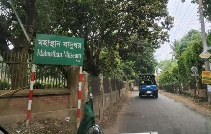
2. Museum.
This museum was established in 1967, 7 km north of Bogra, a little north of Mahasthangarh, just opposite Govinda Vita. At present its extent stands at about 10 acres. Originally the main part of the museum was spread over 3 acres of land and was expanded at various times
Excavations at Mahasthan Gad have yielded thousands of thousands of monuments of the Maurya, Gupta, Pala, Sen and other dynasties, gold, , various precious metals, clay-carved bricks, gold objects, various inscriptions, bronze, silver, stone, , sandstone statues, iron terracotta. Artifacts such as carved idols, sharp weapons for self-defense, black stone idols, bronzes, daily necessities and various types of ancient ornaments have been found which are preserved in the museum located north of Garh. Apart from Mahasthan Gadha, the archaeological remains of various other places are preserved here.
3. Shiladevi Ghat:
On the eastern side of the Garh is the ‘Shiladebi Ghat’ on the banks of the Karatoa River. Parashuram’s sister was Shiladevi. A one-day fair is held here every year and Hindus take bath.
4. Calling step:
It is located in Autobal Mouja of Bogra district.
A. Location.
An archaeological site located 500 meters south-southeast of the Kanai step on the Atonala river flowing about 4.5 km south-west of the Mahasthan museum and on the northern side of Saralpur village on the west bank. The archaeological site is known as Balaidhap.
B. Details.
The archaeological site has been badly damaged by looters. Bricks suggest that there was a Gupta temple here. A number of pottery vessels have been found in the said phase. Excavated in 1926, a gilded bronze Manjushree idol of the Gupta period was recovered from the site. Terracotta art has been found from the side of the mound
5. Treasure Mound;
It is located in Shibganj Upazila of Bogra District and is an archaeological site listed by the Directorate of Archeology of Bangladesh. The structure is located 200 meters south-west of the sixth floor step on the south bank of the Gonrai bil near the treasure mound.
6. Kanji pot mound or Kanji stone steps;
It is located in Shibganj Upazila of Bogra District and is an archaeological site listed by the Directorate of Archeology of Bangladesh. The mound is located about 1 km west of the Khulna steps.
A. Details
Kanji pot mound, width 2 meters length 24 meters and height 4 meters. The ancient bricks of this mound and the bricks that were in the foundation under the soil have been dug out by the locals (like other 10 mounds in Shibganj upazila).
B. Details
The Dhanbhandar mound is 30 meters wide and 45 meters long, with a height of about 9 meters. The mound is filled with ancient bricks and other building materials. Local people believe that there was once a treasure house of Chand Saudagar. Its true identity will be found by excavating the building
7. Glass Courtyard Mound:
It is located in Shibganj Upazila of Bogra District and is an archaeological site listed by the Directorate of Archeology of Bangladesh.
A. Location.
The mound is located on the north bank of Teghar Mauza and Nomrai Beel, about 500 meters due south from the monk’s steps. On top of this mound there were once very beautiful and wonderful archaeological ruins.
B. Details.
The length of the glass courtyard mound is 27 meters, width 24 meters and height 2 meters. The ancient bricks of this mound and the bricks which were in the underground foundation were dug out by the locals. Now the whole place has become a wasteland. The base of this mound is much more than the length.
8. Jyutkund Coupe:
To the west of Shiladevi Ghat in Mahasthan Garh is a large kup called Jyutkund. It is said that by drinking the water of this well, Parashuram’s wounded soldiers would be cured. However, no historical basis has been found for this.
9. Sea of Kalidah:
The western part of the garh houses the historical Kalidah Sagar and the abode of Goddess Padma. Adjacent to Kalidah Sagar is a historic mud fort called Jaripa. Rarunni Snan of Hindus is held every year in the month of March in this ancient sea of Kalidah. After bathing, devotees organize Ganga Puja and Sankirtan ceremony at the seashore.
10. God’s Stone Vita.
God’s Stone is located in Pahar to the east of the Vita shrine. This rectangular Buddhist temple was facing east. It is an elongated and square-shaped morson stone that is not commonly found in nature. It is believed that King Parasurama used to collect it and smooth it for sacrificial purposes. Hindu women used to bathe this stone with milk and vermilion. Still some offer bhakti by pouring milk on this platform with bare feet.
(circa 8th century AD) The remains of this vita are said to date back to the early Pala period. In 1970, some small archaeological remains and a temple were found in this mound or vita. On the top of this mound there is a huge granite stone cairn and from this the local people have given the mound such a strange name. Among the carved stone blocks excavated here, three Buddha images were found seated in a row. which is currently preserved in Varendra Research Museum. The remains of the ancient structure are still buried underground. Only the huge framework can be seen here.
11. Mound of Mankali.
This temple was built by lifelong preacher Mokshali Gosal. It is located on the eastern side of the fun pond in Mahasthangarh. In 1965-66, excavations were started here under the supervision of the Directorate of Archeology and finally several small archaeological objects were discovered, including the ruins of a mosque of the Sultanate period.
The area of the mosque is 26.21 to 14.54 meters. Some remains of a temple were also found under the mosque during the excavation work. No inscriptions have been found on the mosque but archeologists believe that it was probably built before the Mughal period by looking at the structure of the mosque. According to legend, a temple was first built at this place by King Mansingh and his brother Tansingh. According to other legends, the mosque was built here by the zamindars of Ghoraghat. Also, seeing the Jain idols found here, many people think that the place was formerly the residence of Jain priests.
12. Vairagi’s Vita.
Mahasthangarh is situated in the north-east corner of the city, about 200 yards from the house of King Parashuram. The area of this stupa is 300*250 feet.
13. Step of learning.
It is the ruins of a temple. This step is located about 3 km south of Mahasthangarh, about 50 meters upstream of the paved road next to a water body. A Kartika temple is said to have existed at Pandunagar in the Rajatarangini by a scholar named Kalhana in the seventh century AD. This temple at Skanda’s steps is the temple of Kartika. Excavation caused much damage to the mound.
14. Mangalkot Stupa.
Mahasthan is located 1 km west of the mean.
15. Gokul Medha.
2 Kms from Mahasthangarh: Located in south west corner.
16. Tangra Buddhist Stupa.
Tangra is situated at a place called about 45 feet high
17. Bihar step.
Located 6 km North West of Mahasthangarh. The Stupa measures 700*600 feet.
18. Jungle of Vim.
Mahasthangarh is rich in numerous historical buildings, the jungle environment of this Bhima is three sides.
19. Kalidah Sagar.
The western part of the garh contains the historical Kalidah Sagar and the western part of the garh contains the historical Kalidah Sagar and the abode of Goddess Padma. Adjacent to Kalidah Sagar is a historic mud fort called Jaripa. Rarunni Snan of Hindus is held every year in the month of March in this ancient sea of Kalidah. After bathing, devotees organize Ganga Puja and Sankirtan ceremony at the seashore.
20. Govinda Vita:
Govinda Vita is located right in front of Mahasthangarh Museum. Govinda Vita is an excavated archaeological site. The word Govinda Vita means abode of Govinda (Hindu God) aka Vishnu. But no sign of Vaishnava religion was found at this place. Yet the site is locally known as Govinda Vita.
21. Vasu Vihar:
Located 6 km north west of Mahasthangarh and 2 km north of Buddh Vihar.
Vasu Vihar is one of the oldest monuments of Bangladesh. It is located in Shibganj upazila of Bogra district, 6 km west of Mahasthangarh in the village of Vasu Bihar in Bihar Union. Locals know it as Narapati’s step. It is believed to be the ruins of a Sangharam. As a result of the excavation work, various valuable archaeological objects including bronze Buddha images, terracotta plaques have been discovered there.
The ruins of a large number of Buddhist buildings are scattered in Bihar village, about 8 km west of Mahasthan. The ruins of an ancient building measuring 700,600 feet on the banks of the Nagar River, which flows past the village, were identified by Sir Alexander Cunningham in 1879 as Vasu Vihar, described and chronicled by Hiuen Tsang. One of the two Buddhist temples, one larger and the other smaller, was built in the 10th century. The larger one is on the north side and the smaller one is on the south side.
North Side Big Vihar:
Built like a fort, 161 and a half feet in area, 184 feet or 8 and a half feet in length in east and west, 31 rooms of the south facing vihar were built using the thick wall as the back wall. The front walls of the 10 11 or feet area rooms were 6 and a half feet thick. The overall architecture of the vihara with verandah and inner sanctum and 2 guard rooms is similar to that of the smaller vihara on the western side.
Western Small Vihar:
The relatively small Western Vihar is located 75 feet south-west of the large Vihar. The number of rooms in this Vihar was 162 feet long in the north and 152 feet wide in the south which was built with the help of bricks with mud masonry and had 26 rooms. There were 5 rooms on the east side and 7 rooms on the other three sides. This vihara had an entrance hall facing east. The pillared hall was 24 or 19 feet in size.
The front walls of these rooms were 6 and a half feet thick, built using the 8 and a half feet thick Vihar wall as the back wall. The rooms were connected with an eight and a half foot wide veranda surrounded by 3 and a half feet thick walls. In the center of Bihar was a roughly square courtyard measuring 82 or 80 feet. Glimpses of stairs leading to the roof of the vihara have also been found. A staircase of 5 steps leads down to the central courtyard from a small extension from the western verandah.
The work on the exterior walls of this temple was excellent. The walls with curved brick cornices reveal the high artistic sense of its builders.
There was no central temple in this vihara either.
1. Behula’s residence:
About 2 km southwest of Mahasthangarh bus stand is a Buddhist stupa believed to have been built by Emperor Ashoka. The height of the pillar is about 45 feet. In the eastern half of the pillar there is a bathhouse shaped like 24 prominent chowbachchas. It is popularly known as Behula Basar Ghar.
2. Gokul Medh/Behula’s residence.
An archaeological site excavated at Gokul village under Bogra Sadar police station. Locally it is known as Behula Basar Ghar. According to the Bangladesh Directorate of Archaeology, it was built between the 7th century AD and the 12th century AD. It is said that Behula lived here. Which is much earlier than the Sen period. However, according to current researchers, the monument is a Vaidya Math built by Devpal between 809 and 847 AD. A gold leaf with a portrait of a bull was found here along with a small stone fragment with many holes. From this it is assumed that it was a square Shiva temple.
To go to Mahasthangarh you have to go to Bogra first. Its distance from Bogra is about 12 km. And about 2 km from Mahasthangarh bus stand. Yog can be reached by CNG autorickshaw from Bogra town or by bus from Char Matha Bus Terminal. One can reach here from Mahasthangarh in the same way.
Conclusion.
In the course of time, its current name stands as Mahasthangarh. Mahasthangarh is considered to be of archaeological and historical importance for various reasons. Being one of the oldest archaeological sites in South Asia, Mahasthangarh attracts tourists and archaeologists from all over the world.
RSF Model School & College, Bogra